
Mapa topográfico Lake Superior State Park
Mapa interactivo
Haga clic en el mapa para ver la altitud.
Acerca de este mapa
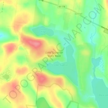
Nombre: Mapa topográfico Lake Superior State Park, altitud, relieve.
Altitud media: 402 m
Altitud mínima: 365 m
Altitud máxima: 445 m
Otros mapas topográficos
Haga clic en un mapa para ver su topografía, su altitud y su relieve.
Mongaup Valley
United States > New York > Sullivan County > Town of Bethel
Mongaup Valley, Town of Bethel, Sullivan County, New York, United States
Altitud media: 380 m