
Mapa topográfico Dead Women Crossing
Mapa interactivo
Haga clic en el mapa para ver la altitud.
Acerca de este mapa
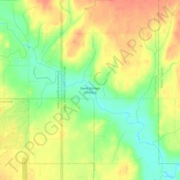
Nombre: Mapa topográfico Dead Women Crossing, altitud, relieve.
Lugar: Dead Women Crossing, Custer County, Oklahoma, United States (35.54783 -98.67091 35.58783 -98.63091)
Altitud media: 482 m
Altitud mínima: 455 m
Altitud máxima: 504 m
Dead Women Crossing, also known as Dead Woman's Crossing, is an unincorporated community on Deer Creek northeast of Weatherford in Custer County, Oklahoma, United States, at an elevation of 1,509 feet (460 m). The community takes its name from the unsolved murder of a local woman.
Otros mapas topográficos
Haga clic en un mapa para ver su topografía, su altitud y su relieve.
Clinton
United States > Oklahoma > Custer County
Clinton, Custer County, Oklahoma, 73601, United States
Altitud media: 481 m