
Mapa topográfico Wels
Mapa interactivo
Haga clic en el mapa para ver la altitud.
Acerca de este mapa
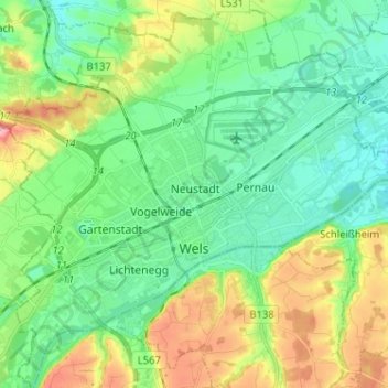
Nombre: Mapa topográfico Wels, altitud, relieve.
Lugar: Wels, Upper Austria, 4600, Austria (48.12582 13.96355 48.21131 14.09076)
Altitud media: 337 m
Altitud mínima: 298 m
Altitud máxima: 423 m
Wels is in the Hausruckviertel at an elevation of 317 m. From north to south, it extends over 9.5 km, from west to east over 9.6 km. 3.4% of the area is covered with forest, 23.5% is used for agriculture.