
Haz una donación
Equípate para tu próxima aventura:
Como asociado de Amazon, este sitio gana comisiones por las compras que califican, sin ningún costo adicional para usted.
Mapa topográfico Danbury
Haga clic en el mapa para ver la altitud.
Haz una donación
Equípate para tu próxima aventura:
Como asociado de Amazon, este sitio gana comisiones por las compras que califican, sin ningún costo adicional para usted.
Danbury
The highest point in Danbury is the summit of Tinkham Hill, at 2,320 feet (710 m) above sea level, in the northern part of town. Ragged Mountain is a prominent mountain with multiple summits which occupies the southern portion of town and has a ski area of the same name; the elevation of the Danbury summit of Ragged is 2,225 ft (678 m) above sea level. The Sunapee-Ragged-Kearsarge Greenway hiking trail crosses a corner of Danbury along Ragged Mountain's Ridge Trail. Access to the Ridge Trail from the SRK Greenway is on the SRKG 6.1 mile trail section 9, either from trailhead parking on New Canada Road in Wilmot from the northwest or from Proctor Academy's trailhead parking in Andover from the southeast.
Haz una donación
Equípate para tu próxima aventura:
Como asociado de Amazon, este sitio gana comisiones por las compras que califican, sin ningún costo adicional para usted.
Acerca de este mapa
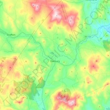
Nombre: Mapa topográfico Danbury, altitud, relieve.
Altitud media: 349 m
Altitud mínima: 138 m
Altitud máxima: 700 m
Haz una donación
Equípate para tu próxima aventura:
Como asociado de Amazon, este sitio gana comisiones por las compras que califican, sin ningún costo adicional para usted.
Otros mapas topográficos
Haga clic en un mapa para ver su topografía, su altitud y su relieve.
Haz una donación
Equípate para tu próxima aventura:
Como asociado de Amazon, este sitio gana comisiones por las compras que califican, sin ningún costo adicional para usted.
Haz una donación
Equípate para tu próxima aventura:
Como asociado de Amazon, este sitio gana comisiones por las compras que califican, sin ningún costo adicional para usted.
Haz una donación
Equípate para tu próxima aventura:
Como asociado de Amazon, este sitio gana comisiones por las compras que califican, sin ningún costo adicional para usted.
Haz una donación
Equípate para tu próxima aventura:
Como asociado de Amazon, este sitio gana comisiones por las compras que califican, sin ningún costo adicional para usted.
Rings Corner
United States > New Hampshire > Merrimack County > Pittsfield > Rings Corner
Altitud media: 190 m