
Haz una donación
Equípate para tu próxima aventura:
Como asociado de Amazon, este sitio gana comisiones por las compras que califican, sin ningún costo adicional para usted.
Mapa topográfico Rapa
Haga clic en el mapa para ver la altitud.
Haz una donación
Equípate para tu próxima aventura:
Como asociado de Amazon, este sitio gana comisiones por las compras que califican, sin ningún costo adicional para usted.
Rapa
Rapa, also called Rapa Iti, or "Little Rapa", to distinguish it from Easter Island, whose Polynesian name is Rapa Nui, is the largest and only inhabited island of the Bass Islands in French Polynesia. An older name for the island is Oparo. The total land area including offshore islets is 40.5 km2 (15.6 sq mi). As of the 2017 census, Rapa had a population of 507. The island's highest point is at 650 metres (2,130 ft) elevation at Mont Perahu. Its main town is Ahuréi. The inhabitants of Rapa Iti speak their own Polynesian language called the Rapa language.
Haz una donación
Equípate para tu próxima aventura:
Como asociado de Amazon, este sitio gana comisiones por las compras que califican, sin ningún costo adicional para usted.
Acerca de este mapa
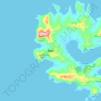
Nombre: Mapa topográfico Rapa, altitud, relieve.
Lugar: Rapa, Austral Islands, French Polynesia, France (-27.64998 -144.38136 -27.56647 -144.30470)
Altitud media: 53 m
Altitud mínima: -4 m
Altitud máxima: 573 m
Haz una donación
Equípate para tu próxima aventura:
Como asociado de Amazon, este sitio gana comisiones por las compras que califican, sin ningún costo adicional para usted.