
Haz una donación
Equípate para tu próxima aventura:
Como asociado de Amazon, este sitio gana comisiones por las compras que califican, sin ningún costo adicional para usted.
Mapa topográfico Cerrina Monferrato
Haga clic en el mapa para ver la altitud.
Haz una donación
Equípate para tu próxima aventura:
Como asociado de Amazon, este sitio gana comisiones por las compras que califican, sin ningún costo adicional para usted.
Cerrina Monferrato
Cerrina Monferrato (population about 1,600) is a commune in the Province of Alessandria in the Italian region Piedmont, located about 40 kilometres (25 mi) east of Turin and about 40 kilometres (25 mi) northwest of Alessandria. Its municipal borders enclose an area of 17.1 square kilometres (6.6 sq mi) ranging in elevation from 158 to 422 metres (518 to 1,385 ft) above sea level. The commune borders Gabiano to the north, Mombello Monferrato to the east, Castelletto Merli and Odalengo Piccolo to the south, and Odalengo Grande and Villamiroglio to the west. The two principal population centres are Valle Cerrina which had a population of 583 at the time of the 2001 census, and Cerrina itself, the historic centre and capoluogo which had a population of 353. Montalero (pop. 35) and Rosingo (pop. 261) were both communes in their own right until 1928. The other settlements include Montaldo, Piancerreto and Gaminella: although the last lies mostly within the commune of Mombello Monferrato.
Haz una donación
Equípate para tu próxima aventura:
Como asociado de Amazon, este sitio gana comisiones por las compras que califican, sin ningún costo adicional para usted.
Acerca de este mapa
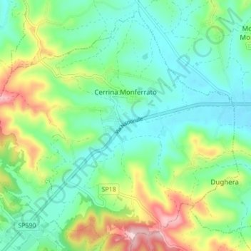
Nombre: Mapa topográfico Cerrina Monferrato, altitud, relieve.
Lugar: Cerrina Monferrato, Alessandria, Piemont, Italy (45.09243 8.17603 45.13708 8.24502)
Altitud media: 233 m
Altitud mínima: 156 m
Altitud máxima: 413 m
Haz una donación
Equípate para tu próxima aventura:
Como asociado de Amazon, este sitio gana comisiones por las compras que califican, sin ningún costo adicional para usted.