
Mapa topográfico Young Harris
Mapa interactivo
Haga clic en el mapa para ver la altitud.
Acerca de este mapa
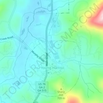
Nombre: Mapa topográfico Young Harris, altitud, relieve.
Lugar: Young Harris, Towns County, Georgia, United States (34.92560 -83.85556 34.94911 -83.83759)
Altitud media: 606 m
Altitud mínima: 547 m
Altitud máxima: 843 m
Otros mapas topográficos
Haga clic en un mapa para ver su topografía, su altitud y su relieve.
Presley
United States > Georgia > Towns County
Presley, Towns County, Georgia, 30546, United States
Altitud media: 653 m
Hiawassee
United States > Georgia > Towns County
Hiawassee, Towns County, Georgia, United States
Altitud media: 620 m
Brasstown Bald
United States > Georgia > Towns County
Brasstown Bald, Towns County, Georgia, United States
Altitud media: 1.161 m