
Haz una donación
Equípate para tu próxima aventura:
Como asociado de Amazon, este sitio gana comisiones por las compras que califican, sin ningún costo adicional para usted.
Mapa topográfico Entoto
Haga clic en el mapa para ver la altitud.
Haz una donación
Equípate para tu próxima aventura:
Como asociado de Amazon, este sitio gana comisiones por las compras que califican, sin ningún costo adicional para usted.
Entoto
The Ethiopian Heritage Trust, a non-profit, non-governmental organization, is working actively to change part of the mountain to its old state, a natural park. Entoto Natural Park is the northeastern rim of Addis Abeba, on the southeastern slopes of Mt. Entoto, covering an area of 1,300 hectares. It is situated at an altitude of between 2,600 and 3,100 meters. Its annual average rainfall and temperature are 1200 mm and 14°C, respectively. The northern rim of the park serves as a watershed between the Abay (Blue Nile) and Awash rivers.
Haz una donación
Equípate para tu próxima aventura:
Como asociado de Amazon, este sitio gana comisiones por las compras que califican, sin ningún costo adicional para usted.
Acerca de este mapa
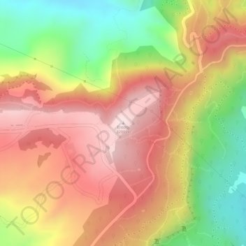
Nombre: Mapa topográfico Entoto, altitud, relieve.
Altitud media: 3.019 m
Altitud mínima: 2.771 m
Altitud máxima: 3.198 m
Haz una donación
Equípate para tu próxima aventura:
Como asociado de Amazon, este sitio gana comisiones por las compras que califican, sin ningún costo adicional para usted.