
Haz una donación
Equípate para tu próxima aventura:
Como asociado de Amazon, este sitio gana comisiones por las compras que califican, sin ningún costo adicional para usted.
Mapa topográfico Hampden
Haga clic en el mapa para ver la altitud.
Haz una donación
Equípate para tu próxima aventura:
Como asociado de Amazon, este sitio gana comisiones por las compras que califican, sin ningún costo adicional para usted.
Hampden
According to the United States Census Bureau, the town has a total area of 19.6 square miles (51 km2), of which 19.6 square miles (51 km2) is land and 0.05% is water. Hampden is located at the eastern edge of the Connecticut River Valley. Hills rise up to over 1,000 feet (300 m) above sea level, from the valley elevation of 150 to 250 feet (46 to 76 m). The highest peaks are Pine Mt. and Rattlesnake Peak, both at 1,070 feet (330 m). The town has no large bodies of water, but has several brooks which eventually drain into the Connecticut River.
Haz una donación
Equípate para tu próxima aventura:
Como asociado de Amazon, este sitio gana comisiones por las compras que califican, sin ningún costo adicional para usted.
Acerca de este mapa
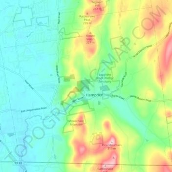
Nombre: Mapa topográfico Hampden, altitud, relieve.
Lugar: Hampden, Hampden County, Massachusetts, 01036, United States (42.03270 -72.46993 42.10313 -72.36699)
Altitud media: 143 m
Altitud mínima: 60 m
Altitud máxima: 328 m
Haz una donación
Equípate para tu próxima aventura:
Como asociado de Amazon, este sitio gana comisiones por las compras que califican, sin ningún costo adicional para usted.