
Mapa topográfico Jamestown
Mapa interactivo
Haga clic en el mapa para ver la altitud.
Acerca de este mapa
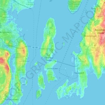
Nombre: Mapa topográfico Jamestown, altitud, relieve.
Altitud media: 8 m
Altitud mínima: -5 m
Altitud máxima: 66 m
Otros mapas topográficos
Haga clic en un mapa para ver su topografía, su altitud y su relieve.
Aquidneck Island
United States > Rhode Island > Newport County > Portsmouth
Aquidneck Island, Portsmouth, Newport County, Rhode Island, United States
Altitud media: 13 m
Goat Island
United States > Rhode Island > Newport County > Newport
Goat Island, Newport, Newport County, Rhode Island, United States
Altitud media: 2 m
Tiverton
United States > Rhode Island > Newport County
Tiverton, Newport County, Rhode Island, 02878, United States
Altitud media: 31 m
Middletown
United States > Rhode Island > Newport County
Middletown, Newport County, Rhode Island, 02842, United States
Altitud media: 19 m
Portsmouth
United States > Rhode Island > Newport County
Portsmouth, Newport County, Rhode Island, United States
Altitud media: 19 m
Narragansett Bay
United States > Rhode Island > Newport County
Narragansett Bay, Newport County, Rhode Island, 02783, United States
Altitud media: 4 m
Little Compton
United States > Rhode Island > Newport County
Little Compton, Newport County, Rhode Island, United States
Altitud media: 9 m
Prudence Island
United States > Rhode Island > Newport County > Portsmouth
Prudence Island, Portsmouth, Newport County, Rhode Island, United States
Altitud media: 6 m
Newport
United States > Rhode Island > Newport County
Newport, Newport County, Rhode Island, 02840, United States
Altitud media: 8 m
Pottersville
United States > Rhode Island > Newport County > Little Compton > Pottersville
Pottersville, Little Compton, Newport County, Rhode Island, 02837, United States
Altitud media: 17 m