
Mapa topográfico Yamanouchi
Mapa interactivo
Haga clic en el mapa para ver la altitud.
Acerca de este mapa
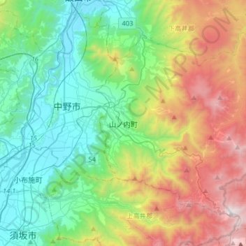
Nombre: Mapa topográfico Yamanouchi, altitud, relieve.
Altitud media: 942 m
Altitud mínima: 305 m
Altitud máxima: 2.303 m
Shimotakai District, in northern mountainous Nagano Prefecture, comprises Yamanouchi town, Kijimadaira Village, and Nozawaonsen Village. Yamanouchi is the largest of these. More than 90% of Yamanouchi is covered by mountains and forests. The town measures approximately 39 kilometers east-west and 12 kilometers north-south (266 square kilometers), and has an elevation ranging from 424 meters to 2341 meters. The surrounding area is known for its forest therapy.