
Mapa topográfico Salton Sea
Mapa interactivo
Haga clic en el mapa para ver la altitud.
Salton Sea
The Gulf of California would extend as far north as the city of Indio, some 150 miles (240 km) northwest of its current limits, were it not for the delta created by the Colorado River. Over three million years, through all of the Pleistocene, the river's delta expanded until it cut off the northern part of the gulf. Since then, the Colorado River has alternated between emptying into the basin, creating a freshwater lake, and emptying into the gulf, leaving the lake to dry and turn to desert. Wave-cut shorelines at various elevations record a repeated cycle of filling and drying over hundreds of thousands of years. The most recent freshwater lake was Lake Cahuilla, also known as the Blake Sea after American professor and geologist William Phipps Blake. It covered over 2,000 square miles (5,200 km2), six times the area of the Salton Sea.
Acerca de este mapa
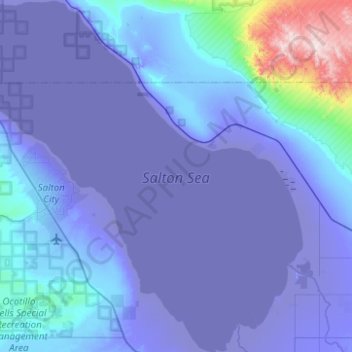
Nombre: Mapa topográfico Salton Sea, altitud, relieve.
Lugar: Salton Sea, Imperial County, California, United States (33.10833 -116.07614 33.52326 -115.60321)
Altitud media: 9 m
Altitud mínima: -73 m
Altitud máxima: 897 m
Otros mapas topográficos
Haga clic en un mapa para ver su topografía, su altitud y su relieve.
Seeley
United States > California > Imperial County > Seeley
NAF El Centro, the winter home of the Blue Angels, was built adjacent to Seeley in 1946. In 1964, Interstate 8 was run a mile south of Seeley, marking the lowest elevation on the Interstate Highway System at -52 feet.
Altitud media: -11 m
Salton City
United States > California > Imperial County > Salton City
In the 1970s, most of the buildings constructed along the shoreline, including the city's marina were abandoned due to rising sea elevation. In the 1980s, the Imperial Irrigation District took proactive water conservation measures to reduce the flow of unused canal water into the Salton Sea. Throughout the…
Altitud media: -35 m
Salton City
United States > California > Imperial County
In the 1970s, most of the buildings constructed along the shoreline, including the city's marina were abandoned due to rising sea elevation. In the 1980s, the Imperial Irrigation District took proactive water conservation measures to reduce the flow of unused canal water into the Salton Sea. Throughout the…
Altitud media: -40 m
Brawley
United States > California > Imperial County
Brawley is located in the Colorado Desert and Lower Colorado River Valley regions. The city's elevation, like other Imperial Valley towns, is below sea level.
Altitud media: -37 m
Brawley
United States > California > Imperial County
Brawley is located in the Colorado Desert and Lower Colorado River Valley regions. The city's elevation, like other Imperial Valley towns, is below sea level.
Altitud media: -37 m
Calipatria
United States > California > Imperial County
At an elevation of 180 feet (55 m) below sea level, Calipatria is the lowest incorporated city in the Western Hemisphere. The city currently claims to have the "tallest flagpole (184 feet) where the flag flies at sea level" at 184 feet (56 m), so their American flag will always fly above sea level. According…
Altitud media: -54 m