
Mapa topográfico Worthington
Mapa interactivo
Haga clic en el mapa para ver la altitud.
Acerca de este mapa
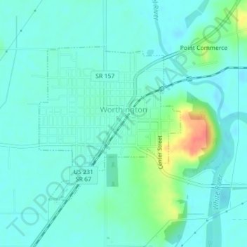
Nombre: Mapa topográfico Worthington, altitud, relieve.
Lugar: Worthington, Greene County, Indiana, 47471, United States (39.10864 -86.98852 39.12543 -86.96858)
Altitud media: 162 m
Altitud mínima: 150 m
Altitud máxima: 204 m
Otros mapas topográficos
Haga clic en un mapa para ver su topografía, su altitud y su relieve.
Switz City
United States > Indiana > Greene County
Switz City, Greene County, Indiana, 47465, United States
Altitud media: 162 m
Linton
United States > Indiana > Greene County
Linton, Greene County, Indiana, 47441, United States
Altitud media: 161 m
Bloomfield
United States > Indiana > Greene County
Bloomfield, Greene County, Indiana, 47424, United States
Altitud media: 168 m
Shakamak State Park
United States > Indiana > Greene County
Shakamak State Park, Greene County, Indiana, United States
Altitud media: 175 m
White Rose
United States > Indiana > Greene County
White Rose, Greene County, Indiana, United States
Altitud media: 156 m
Owensburg
United States > Indiana > Greene County > Owensburg
Owensburg, Greene County, Indiana, 47453, United States
Altitud media: 223 m