
Mapa topográfico Leicester
Mapa interactivo
Haga clic en el mapa para ver la altitud.
Acerca de este mapa
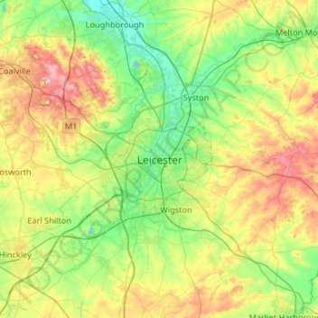
Nombre: Mapa topográfico Leicester, altitud, relieve.
Lugar: Leicester, Leicestershire, England, LE1 5YA, United Kingdom (52.47620 -1.29320 52.79620 -0.97320)
Altitud media: 109 m
Altitud mínima: 33 m
Altitud máxima: 269 m
Otros mapas topográficos
Haga clic en un mapa para ver su topografía, su altitud y su relieve.
Blackfordby
United Kingdom > England > Leicestershire > North West Leicestershire
Blackfordby, North West Leicestershire, Leicestershire, England, DE11 8AP, United Kingdom
Altitud media: 135 m