
Mapa topográfico Palatine Hill
Mapa interactivo
Haga clic en el mapa para ver la altitud.
Acerca de este mapa
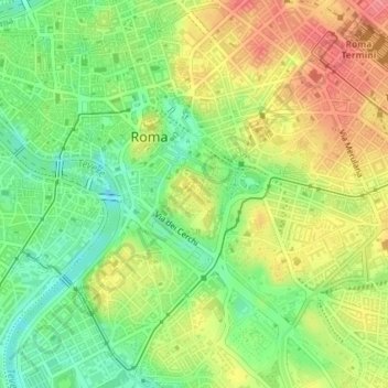
Nombre: Mapa topográfico Palatine Hill, altitud, relieve.
Altitud media: 40 m
Altitud mínima: 3 m
Altitud máxima: 79 m
In 2007 the legendary Lupercal cave was claimed to have been found beneath the remains of the Domus Livia (House of Livia) on the Palatine. Archaeologists came across the 16-metre-deep cavity while restoring the decaying palace, with a richly decorated vault encrusted with mosaics and seashells. The Lupercal was probably converted to a sanctuary by Romans in later centuries. Many others have denied its identification with the Lupercal on topographic and stylistic grounds, and believe that the grotto is actually a nymphaeum or underground triclinium from Neronian times.
Otros mapas topográficos
Haga clic en un mapa para ver su topografía, su altitud y su relieve.
Casal Monastero
Italy > Lazio > Roma Capitale > Rome
Casal Monastero, Rome, Roma Capitale, Lazio, 00131, Italy
Altitud media: 41 m
Infernetto
Italy > Lazio > Roma Capitale > Rome
Infernetto, Rome, Roma Capitale, Lazio, 00124, Italy
Altitud media: 25 m
Fontana di piazza dell'Aracoeli
Italy > Lazio > Roma Capitale > Rome
Fontana di piazza dell'Aracoeli, Campitelli, Municipio Roma I, Rome, Roma Capitale, Lazio, Italy
Altitud media: 39 m