
Mapa topográfico Bembridge Harbour
Mapa interactivo
Haga clic en el mapa para ver la altitud.
Acerca de este mapa
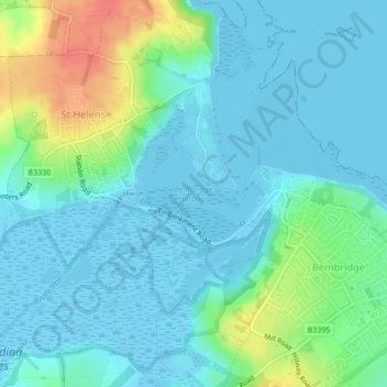
Nombre: Mapa topográfico Bembridge Harbour, altitud, relieve.
Altitud media: 12 m
Altitud mínima: -8 m
Altitud máxima: 50 m
Otros mapas topográficos
Haga clic en un mapa para ver su topografía, su altitud y su relieve.
Hillway
United Kingdom > England > Isle of Wight > Bembridge
Hillway, Bembridge, Isle of Wight, England, PO35 5PN, United Kingdom
Altitud media: 18 m