
Mapa topográfico Mai Châu District
Mapa interactivo
Haga clic en el mapa para ver la altitud.
Acerca de este mapa
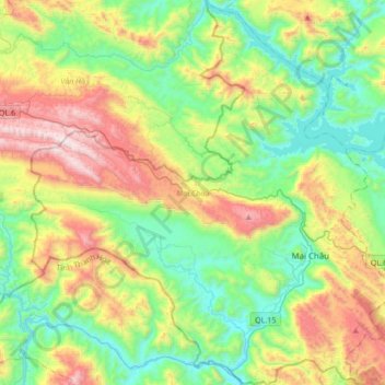
Nombre: Mapa topográfico Mai Châu District, altitud, relieve.
Lugar: Mai Châu District, Hoà Bình province, Vietnam (20.55722 104.83648 20.87561 105.15879)
Altitud media: 549 m
Altitud mínima: 74 m
Altitud máxima: 1.504 m
Mai Châu is a mountainous region located in Hòa Bình Province, approximately 135 km from Hanoi and 65 km from Hòa Bình. The east of Mai Châu borders Đà Bắc and Tân Lạc districts, the west and the south border Quan Hóa district of Thanh Hóa province, and the north borders Vân Hồ district of Sơn La province. Mai Châu's terrain is quite complex, divided by slits, streams and high mountains. According to the topographic characteristics, Mai Châu can be divided into two distinct areas: the low region (relatively flat terrain with fertile soil) and the high region (with many high and rugged mountain ranges).
Otros mapas topográficos
Haga clic en un mapa para ver su topografía, su altitud y su relieve.
Yên Thủy District
Yên Thủy District, Hoà Bình province, Vietnam
Altitud media: 125 m
Bản Lác
Vietnam > Hoa Binh province > Mai Châu District > Chiềng Châu
Bản Lác, Chiềng Châu, Mai Châu District, Hoà Bình province, Vietnam
Altitud media: 279 m
Tân Lạc District
Tân Lạc District, Hoà Bình province, Vietnam
Altitud media: 416 m