
Haz una donación
Equípate para tu próxima aventura:
Como asociado de Amazon, este sitio gana comisiones por las compras que califican, sin ningún costo adicional para usted.
Mapa topográfico Bintan Island
Haga clic en el mapa para ver la altitud.
Haz una donación
Equípate para tu próxima aventura:
Como asociado de Amazon, este sitio gana comisiones por las compras que califican, sin ningún costo adicional para usted.
Bintan Island
Bintan, is the largest among the 3,200 islands of Riau Archipelago and is located 10 kilometres (6.2 mi) east of the Batam Island. It has a coast line of 105 kilometres (65 mi) and has rolling topography in its landform. The Riau Islands are a province of Indonesia, which encompassed the Riau Archipelago, Natuna Islands, Anambas, and Lingga Islands; in July 2004 the islands of Riau were divided from the existing Riau Province to form the new province with its capital at Tanjung Pinang. The archipelagos of Anambas and Natuna, located between mainland Malaysia and Borneo, are now part of this province
Haz una donación
Equípate para tu próxima aventura:
Como asociado de Amazon, este sitio gana comisiones por las compras que califican, sin ningún costo adicional para usted.
Acerca de este mapa
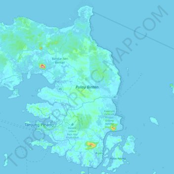
Nombre: Mapa topográfico Bintan Island, altitud, relieve.
Lugar: Bintan Island, Bintan, Riau Islands, Sumatra, Indonesia (0.80955 104.21381 1.22980 104.66254)
Altitud media: 6 m
Altitud mínima: -4 m
Altitud máxima: 323 m
Haz una donación
Equípate para tu próxima aventura:
Como asociado de Amazon, este sitio gana comisiones por las compras que califican, sin ningún costo adicional para usted.
Otros mapas topográficos
Haga clic en un mapa para ver su topografía, su altitud y su relieve.