
Mapa topográfico Center Point
Mapa interactivo
Haga clic en el mapa para ver la altitud.
Acerca de este mapa
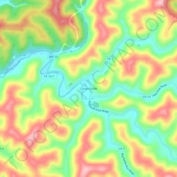
Nombre: Mapa topográfico Center Point, altitud, relieve.
Altitud media: 312 m
Altitud mínima: 229 m
Altitud máxima: 403 m
Center Point is an unincorporated community in northeastern Doddridge County, West Virginia, USA. It lies along Route 23 northeast of the town of West Union, the county seat of Doddridge County. Its elevation is 791 feet (241 m).
Otros mapas topográficos
Haga clic en un mapa para ver su topografía, su altitud y su relieve.
Talkington Fork McElroy Creek
United States > West Virginia > Center Point
Talkington Fork McElroy Creek, Center Point, Doddridge County, West Virginia, 26339, United States
Altitud media: 300 m