
Haz una donación
Equípate para tu próxima aventura:
Como asociado de Amazon, este sitio gana comisiones por las compras que califican, sin ningún costo adicional para usted.
Mapa topográfico Hogeye
Haga clic en el mapa para ver la altitud.
Haz una donación
Equípate para tu próxima aventura:
Como asociado de Amazon, este sitio gana comisiones por las compras que califican, sin ningún costo adicional para usted.
Acerca de este mapa
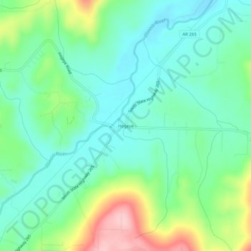
Nombre: Mapa topográfico Hogeye, altitud, relieve.
Lugar: Hogeye, Washington County, Arkansas, United States (35.90036 -94.28771 35.94036 -94.24771)
Altitud media: 414 m
Altitud mínima: 362 m
Altitud máxima: 541 m
Haz una donación
Equípate para tu próxima aventura:
Como asociado de Amazon, este sitio gana comisiones por las compras que califican, sin ningún costo adicional para usted.
Otros mapas topográficos
Haga clic en un mapa para ver su topografía, su altitud y su relieve.
Fayetteville
United States > Arkansas > Washington County
Fayetteville is nestled in the picturesque Ozark Mountains, characterized by rolling hills, lush forests, and scenic valleys that define the region's topography. The elevation in Fayetteville ranges from about 1,100 feet to over 1,500 feet above sea level, creating a varied landscape that features steep ridges…
Altitud media: 401 m
Greenland
United States > Arkansas > Washington County
The climate in this area is characterized by hot, extremely humid summers and generally cool to very cold winters depending on elevation. According to the Köppen Climate Classification system, Greenland has a humid subtropical climate, abbreviated "Cfa" on climate maps.
Altitud media: 419 m
West Fork
United States > Arkansas > Washington County
West Fork is located at 35°56′08″N 94°10′48″W / 35.93556°N 94.18000°W / 35.93556; -94.18000 (35.9356771, -94.1801038) at an elevation of 1,358 feet (414 m). According to the United States Census Bureau, the city has a total area of 3.3 square miles (8.5 km2), all land.
Altitud media: 468 m
Haz una donación
Equípate para tu próxima aventura:
Como asociado de Amazon, este sitio gana comisiones por las compras que califican, sin ningún costo adicional para usted.
Haz una donación
Equípate para tu próxima aventura:
Como asociado de Amazon, este sitio gana comisiones por las compras que califican, sin ningún costo adicional para usted.
Fayetteville
United States > Arkansas > Washington County
...yet I venture the assertion that nowhere in said country—or for that matter, in any part of the state—could be found a lovelier elevation, or a lovelier grove of graceful oaks, or a more commanding view, or, in fine, a spot better suited and adapted for the purposes designated than the one chosen for…
Altitud media: 401 m
Haz una donación
Equípate para tu próxima aventura:
Como asociado de Amazon, este sitio gana comisiones por las compras que califican, sin ningún costo adicional para usted.
Haz una donación
Equípate para tu próxima aventura:
Como asociado de Amazon, este sitio gana comisiones por las compras que califican, sin ningún costo adicional para usted.
Fayetteville
United States > Arkansas > Washington County
...yet I venture the assertion that nowhere in said country—or for that matter, in any part of the state—could be found a lovelier elevation, or a lovelier grove of graceful oaks, or a more commanding view, or, in fine, a spot better suited and adapted for the purposes designated than the one chosen for…
Altitud media: 401 m