
Haz una donación
Equípate para tu próxima aventura:
Como asociado de Amazon, este sitio gana comisiones por las compras que califican, sin ningún costo adicional para usted.
Mapa topográfico Clanwilliam
Haga clic en el mapa para ver la altitud.
Haz una donación
Equípate para tu próxima aventura:
Como asociado de Amazon, este sitio gana comisiones por las compras que califican, sin ningún costo adicional para usted.
Clanwilliam
Clanwilliam is situated at an elevation of 100 metres (330 ft), between the western slopes of the Cederberg mountains and the east bank of the Olifants River, which is impounded there by the Clanwilliam Dam. It lies just off the N7 national road, which runs from Cape Town to the Namibian border, and on the R364 road, which runs from Lamberts Bay to Calvinia. Clanwilliam is 230 kilometres (140 mi) from Cape Town by road.
Haz una donación
Equípate para tu próxima aventura:
Como asociado de Amazon, este sitio gana comisiones por las compras que califican, sin ningún costo adicional para usted.
Acerca de este mapa
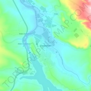
Nombre: Mapa topográfico Clanwilliam, altitud, relieve.
Altitud media: 162 m
Altitud mínima: 72 m
Altitud máxima: 536 m
Haz una donación
Equípate para tu próxima aventura:
Como asociado de Amazon, este sitio gana comisiones por las compras que califican, sin ningún costo adicional para usted.
Otros mapas topográficos
Haga clic en un mapa para ver su topografía, su altitud y su relieve.
Bulshoek Dam
South Africa > Western Cape > West Coast District Municipality > Cederberg Local Municipality
Altitud media: 184 m
Cederberg Ward 1
South Africa > Western Cape > West Coast District Municipality > Cederberg Local Municipality
Altitud media: 690 m
Clanwilliam Dam
South Africa > Western Cape > West Coast District Municipality > Cederberg Local Municipality > Clanwilliam
Altitud media: 289 m
Krom
South Africa > Western Cape > West Coast District Municipality > Cederberg Local Municipality
Altitud media: 870 m
Haz una donación
Equípate para tu próxima aventura:
Como asociado de Amazon, este sitio gana comisiones por las compras que califican, sin ningún costo adicional para usted.