
Mapa topográfico Chryston
Haga clic en el mapa para ver la altitud.
Acerca de este mapa
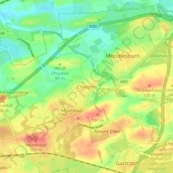
Nombre: Mapa topográfico Chryston, altitud, relieve.
Lugar: Chryston, North Lanarkshire, Scotland, G69 9LL, United Kingdom (55.88646 -4.11931 55.92646 -4.07931)
Altitud media: 78 m
Altitud mínima: 52 m
Altitud máxima: 107 m
Otros mapas topográficos
Haga clic en un mapa para ver su topografía, su altitud y su relieve.
Cumbernauld
United Kingdom > Scotland > North Lanarkshire
Cumbernauld's name probably comes from the Gaelic comar nan allt, meaning "meeting of the burns or streams". There are differing views as to the etymology of this. One theory is that from its high point in the Central Belt, its streams flow both west to the River Clyde and east to the Firth of Forth so…
Altitud media: 113 m