
Haz una donación
Equípate para tu próxima aventura:
Como asociado de Amazon, este sitio gana comisiones por las compras que califican, sin ningún costo adicional para usted.
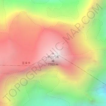
Mapa topográfico Molamenqing
Haga clic en el mapa para ver la altitud.
Haz una donación
Equípate para tu próxima aventura:
Como asociado de Amazon, este sitio gana comisiones por las compras que califican, sin ningún costo adicional para usted.
Molamenqing
Molamenqing, also known as Phola Gangchen, is an eastern outlier of Shishapangma, the 14th-highest peak in the world. Both are in the Jugal Himal, a subrange of the Himalaya in Tibet. (This range is contiguous with, and often considered a part of, the Langtang Himal.) Its elevation is also given as 7,661 m (25,135 ft); the elevation given here is from a Chinese survey. Molamenqing is little-known, partly since it does not have much independent stature. Its topographic prominence, i.e. its rise above the saddle connecting it with Shishapangma, is only 430 metres, which is relatively small for a Himalayan peak, although large enough for it to qualify in some reckonings as an independent peak.
Haz una donación
Equípate para tu próxima aventura:
Como asociado de Amazon, este sitio gana comisiones por las compras que califican, sin ningún costo adicional para usted.
Acerca de este mapa
Nombre: Mapa topográfico Molamenqing, altitud, relieve.
Altitud media: 6.756 m
Altitud mínima: 5.658 m
Altitud máxima: 7.655 m
Haz una donación
Equípate para tu próxima aventura:
Como asociado de Amazon, este sitio gana comisiones por las compras que califican, sin ningún costo adicional para usted.