
Mapa topográfico Kilfinnane
Haga clic en el mapa para ver la altitud.
Kilfinnane
At an elevation of over 150 metres (500 ft), Kilfinnane is the highest town in County Limerick. It is surrounded on three sides by the Ballyhoura Mountains, and on the fourth side is the "Golden Vale" region that runs through Counties Limerick, Cork, and Tipperary.
Acerca de este mapa
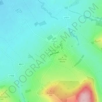
Nombre: Mapa topográfico Kilfinnane, altitud, relieve.
Altitud media: 160 m
Altitud mínima: 108 m
Altitud máxima: 316 m
Otros mapas topográficos
Haga clic en un mapa para ver su topografía, su altitud y su relieve.
Kilcruaig
Ireland > County Limerick > The Municipal District of Cappamore — Kilmallock
Altitud media: 200 m
Knockadea
Ireland > County Limerick > The Municipal District of Cappamore — Kilmallock
Altitud media: 203 m
Pallasgreen
Ireland > County Limerick > The Municipal District of Cappamore — Kilmallock
Altitud media: 72 m
Galtymore
Ireland > County Limerick > The Municipal District of Cappamore — Kilmallock
Galtymore or Galteemore (Irish: Cnoc Mór na nGaibhlte, meaning 'big hill of the Galtees') is a mountain in the province of Munster, Ireland. At 917.9 metres (3,011 ft 6 in), it is one of Ireland's highest mountains, being the 12th-highest on the Arderin list, and 14th-highest on the Vandeleur-Lynam list.…
Altitud media: 594 m
Aherlow
Ireland > County Limerick > The Municipal District of Cappamore — Kilmallock
Altitud media: 141 m
Clare Glens
Ireland > County Limerick > The Municipal District of Cappamore — Kilmallock
Altitud media: 124 m
Ardpatrick
Ireland > County Limerick > The Municipal District of Cappamore — Kilmallock
Altitud media: 169 m
Bruff
Ireland > County Limerick > The Municipal District of Cappamore — Kilmallock
Altitud media: 68 m
Bruree
Ireland > County Limerick > The Municipal District of Cappamore — Kilmallock
Altitud media: 62 m