
Mapa topográfico Raynesford
Mapa interactivo
Haga clic en el mapa para ver la altitud.
Acerca de este mapa
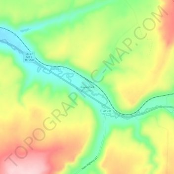
Nombre: Mapa topográfico Raynesford, altitud, relieve.
Altitud media: 1.305 m
Altitud mínima: 1.200 m
Altitud máxima: 1.425 m
Raynesford is an unincorporated community in Judith Basin County, Montana, United States. Its elevation is 4,042 feet (1,232 m), and it is located at 47°16′12″N 110°43′48″W / 47.27000°N 110.73000°W / 47.27000; -110.73000 (47.2699643, -110.7299417). The community includes a community center, a catholic church, a fire department, and a post office. The post office was established under the name of "Spion Kop" on March 31, 1906; its name was changed to Raynesford exactly three years later.
Otros mapas topográficos
Haga clic en un mapa para ver su topografía, su altitud y su relieve.
Stanford
United States > Montana > Judith Basin County
Stanford, Judith Basin County, Montana, 59579, United States
Altitud media: 1.304 m