
Mapa topográfico Baco
Haga clic en el mapa para ver la altitud.
Baco
Majority of the barangays of the municipality are in lowland areas or below 500 meters above sea level (MASL) and cover 41.88 percent of the total land area (13,035.58 ha). The three largest barangays, which cover most of the forestland, have an elevation that ranges from 500-1,000 and greater than 1,000 meters above sea level. Moreover, Mount Halcon, which is found in Bayanan and Lantuyang, has the highest elevation in the entire province of Oriental Mindoro with an estimated height of 2,590 meters above sea level.
Acerca de este mapa
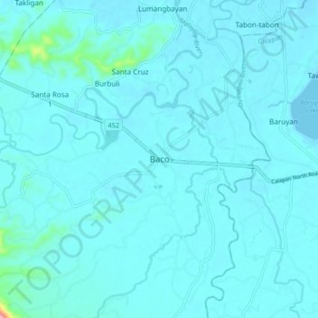
Nombre: Mapa topográfico Baco, altitud, relieve.
Lugar: Baco, Oriental Mindoro, Mimaropa, Philippines (13.31810 121.05633 13.39810 121.13633)
Altitud media: 14 m
Altitud mínima: 0 m
Altitud máxima: 204 m
Otros mapas topográficos
Haga clic en un mapa para ver su topografía, su altitud y su relieve.
Calapan
Philippines > Oriental Mindoro
The overall land characteristic is a wide plain with rivers, interspersed with wetlands at the seacoast periphery. The highest elevation is 187 m (614 ft) above sea level at Bulusan Hill, a 6-kilometre (3.7 mi) long landform east of the city, which interrupts the mostly flat terrain north-east of the…
Altitud media: 12 m
Naujan Lake
Philippines > Oriental Mindoro > Malabo
Mount Naujan, elevation 1,380 feet (420 m) and one of the inactive volcanoes of the country, is situated northeast of the geographic center of the lake. Several thermal springs and solfataras are reported to exist on the eastern border of the Naujan Lake.
Altitud media: 46 m
Calapan
Philippines > Oriental Mindoro
The overall land characteristic is a wide plain with rivers, interspersed with wetlands at the seacoast periphery. The highest elevation is 187 m (614 ft) above sea level at Bulusan Hill, a 6-kilometre (3.7 mi) long landform east of the city, which interrupts the mostly flat terrain north-east of the…
Altitud media: 12 m