
Mapa topográfico Mastuj Tehsil
Mapa interactivo
Haga clic en el mapa para ver la altitud.
Acerca de este mapa
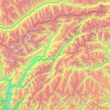
Nombre: Mapa topográfico Mastuj Tehsil, altitud, relieve.
Altitud media: 4.143 m
Altitud mínima: 1.426 m
Altitud máxima: 7.626 m
Mastuj (Urdu: مستوج) is a tehsil of Upper Chitral District in Khyber-Pakhtunkhwa province of Pakistan; Mastuj is the principal settlement. It is located at 36°17'0N 72°31'0E with an altitude of 2359 metres (7742 feet). There are ruins of old fort built originally in 18th century and reconstructed several times.
Otros mapas topográficos
Haga clic en un mapa para ver su topografía, su altitud y su relieve.
Buni Zom
Pakistan > Khyber Pakhtunkhwa > Chitrāl District > Mastuj Tehsil
Buni Zom, Mastuj Tehsil, Upper Chitral District, Chitrāl District, Malakand Division, Khyber Pakhtunkhwa, Pakistan
Altitud media: 5.757 m
Drosh Tehsil
Pakistan > Khyber Pakhtunkhwa > Chitrāl District
Drosh Tehsil, Lower Chitral District, Chitrāl District, Malakand Division, Khyber Pakhtunkhwa, 17220, Pakistan
Altitud media: 3.012 m
Koyo Zom
Pakistan > Khyber Pakhtunkhwa > Chitrāl District
Koyo Zom, Upper Chitral District, Chitrāl District, Malakand Division, Khyber Pakhtunkhwa, Pakistan
Altitud media: 5.925 m
Gree
Pakistan > Khyber Pakhtunkhwa > Chitrāl District > Chitral Tehsil
Gree, Chitral Tehsil, Lower Chitral District, Chitrāl District, Malakand Division, Khyber Pakhtunkhwa, Pakistan
Altitud media: 2.883 m
Hindu Kush
Pakistan > Khyber Pakhtunkhwa > Chitrāl District > Chitral Tehsil
Hindu Kush, Chitral Tehsil, Lower Chitral District, Chitrāl District, Malakand Division, Khyber Pakhtunkhwa, Pakistan
Altitud media: 5.281 m
Chitral
Pakistan > Khyber Pakhtunkhwa > Chitrāl District
Chitral, Chitral Tehsil, Lower Chitral District, Chitrāl District, Malakand Division, Khyber Pakhtunkhwa, Pakistan
Altitud media: 2.982 m