
Mapa topográfico Danville
Mapa interactivo
Haga clic en el mapa para ver la altitud.
Acerca de este mapa
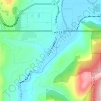
Nombre: Mapa topográfico Danville, altitud, relieve.
Lugar: Danville, Ferry County, Washington, 99121, United States (48.97240 -118.52808 49.01240 -118.48808)
Altitud media: 638 m
Altitud mínima: 522 m
Altitud máxima: 1.047 m
Otros mapas topográficos
Haga clic en un mapa para ver su topografía, su altitud y su relieve.
Keller
United States > Washington > Ferry County
Keller, Ferry County, Washington, 99140, United States
Altitud media: 536 m
Inchelium
United States > Washington > Ferry County
Inchelium, Ferry County, Washington, United States
Altitud media: 639 m
Laurier
United States > Washington > Ferry County
Laurier, Ferry County, Washington, 99146, United States
Altitud media: 604 m
Malo
United States > Washington > Ferry County
Malo, Ferry County, Washington, 99160, United States
Altitud media: 788 m
Orient
United States > Washington > Ferry County
Orient, Ferry County, Washington, United States
Altitud media: 598 m
Republic
United States > Washington > Ferry County
Republic, Ferry County, Washington, United States
Altitud media: 826 m
Curlew
United States > Washington > Ferry County
Curlew, Ferry County, Washington, United States
Altitud media: 672 m
Wiseman Island
United States > Washington > Ferry County > Pollard
Wiseman Island, Pollard, Ferry County, Washington, United States
Altitud media: 777 m