
Haz una donación
Equípate para tu próxima aventura:
Como asociado de Amazon, este sitio gana comisiones por las compras que califican, sin ningún costo adicional para usted.
Mapa topográfico Meridian
Haga clic en el mapa para ver la altitud.
Haz una donación
Equípate para tu próxima aventura:
Como asociado de Amazon, este sitio gana comisiones por las compras que califican, sin ningún costo adicional para usted.
Meridian
Meridian is located in the East Central Hills region of Mississippi in Lauderdale County. According to the United States Census Bureau, the city has a total area of 54.50 square miles (141.2 km2), of which 53.74 square miles (139.2 km2) are land and 0.76 square miles (2.0 km2), or 1.40%, are water. Along major highways, the city is 93 mi (150 km) east of Jackson, Mississippi; 154 mi (248 km) west of Birmingham, Alabama; 202 mi (325 km) northeast of New Orleans, Louisiana; 231 mi (372 km) southeast of Memphis, Tennessee; and 297 mi (478 km) west of Atlanta, Georgia. The area surrounding the city is covered with oak and pine forests, and its topography consists of clay hills and the bottom lands of the head waters of the Chickasawhay River.
Haz una donación
Equípate para tu próxima aventura:
Como asociado de Amazon, este sitio gana comisiones por las compras que califican, sin ningún costo adicional para usted.
Acerca de este mapa
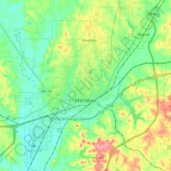
Nombre: Mapa topográfico Meridian, altitud, relieve.
Lugar: Meridian, Lauderdale County, Mississippi, United States (32.31238 -88.77360 32.43978 -88.61034)
Altitud media: 118 m
Altitud mínima: 78 m
Altitud máxima: 205 m
Haz una donación
Equípate para tu próxima aventura:
Como asociado de Amazon, este sitio gana comisiones por las compras que califican, sin ningún costo adicional para usted.
Otros mapas topográficos
Haga clic en un mapa para ver su topografía, su altitud y su relieve.