
Haz una donación
Equípate para tu próxima aventura:
Como asociado de Amazon, este sitio gana comisiones por las compras que califican, sin ningún costo adicional para usted.
Mapa topográfico Akutan Island
Haga clic en el mapa para ver la altitud.
Haz una donación
Equípate para tu próxima aventura:
Como asociado de Amazon, este sitio gana comisiones por las compras que califican, sin ningún costo adicional para usted.
Acerca de este mapa
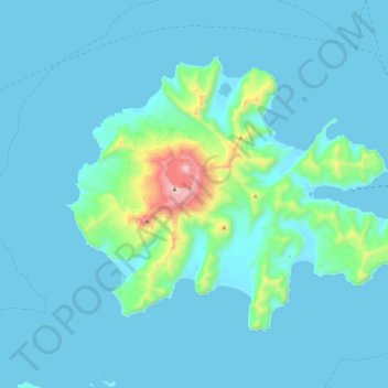
Nombre: Mapa topográfico Akutan Island, altitud, relieve.
Altitud media: 102 m
Altitud mínima: -4 m
Altitud máxima: 1.278 m
Haz una donación
Equípate para tu próxima aventura:
Como asociado de Amazon, este sitio gana comisiones por las compras que califican, sin ningún costo adicional para usted.
Otros mapas topográficos
Haga clic en un mapa para ver su topografía, su altitud y su relieve.
Shishaldin Volcano
United States > Alaska > Aleutians East Borough
Shishaldin is located on Unimak Island, the easternmost of the Aleutian Islands. The nearest settlement to the volcano is False Pass (population ~100) at 45 km away. The view of Shishaldin from False Pass is obscured by the Round Top and Isanotski volcanoes, preventing direct observations of eruptions in many…
Altitud media: 2.134 m
Haz una donación
Equípate para tu próxima aventura:
Como asociado de Amazon, este sitio gana comisiones por las compras que califican, sin ningún costo adicional para usted.