
Mapa topográfico Kilsyth
Mapa interactivo
Haga clic en el mapa para ver la altitud.
Kilsyth
Historically part of Stirlingshire, Kilsyth is at an elevation of 200 feet (60 metres) above sea level and occupies a narrow strip of land between the Kilsyth Hills to the north and the River Kelvin to the south. To the east and west it is bordered by marshland and bogs. The centre of the town is close to the confluence of the Garrell and Ebroch burns.
Acerca de este mapa
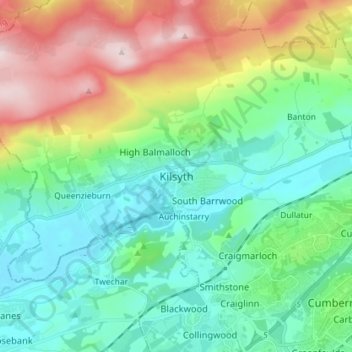
Nombre: Mapa topográfico Kilsyth, altitud, relieve.
Lugar: Kilsyth, North Lanarkshire, Scotland, G65 0AQ, United Kingdom (55.93654 -4.09597 56.01654 -4.01597)
Altitud media: 161 m
Altitud mínima: 34 m
Altitud máxima: 462 m