
Haz una donación
Equípate para tu próxima aventura:
Como asociado de Amazon, este sitio gana comisiones por las compras que califican, sin ningún costo adicional para usted.
Mapa topográfico Fribourg - Freiburg
Haga clic en el mapa para ver la altitud.
Haz una donación
Equípate para tu próxima aventura:
Como asociado de Amazon, este sitio gana comisiones por las compras que califican, sin ningún costo adicional para usted.
Fribourg - Freiburg
Fribourg has an elevation of 581 metres (1,906 ft) (in the Old City), and is situated 28 kilometres (17 mi) southwest of Bern. It is located on the Swiss plateau, and extends on both sides of the Sarine, which, in the vicinity of Fribourg, has cut deeply into the molasse. The Old City is located on a hill, only about 100 metres (330 ft) wide, which rises about 40 metres (130 ft) above the valley floor. Most quarters of the city are located on the High Plateau and the surrounding hills, which have an average elevation of 620 metres (2,030 ft). The valley floor is only settled in the area immediately around the Old City.
Haz una donación
Equípate para tu próxima aventura:
Como asociado de Amazon, este sitio gana comisiones por las compras que califican, sin ningún costo adicional para usted.
Acerca de este mapa
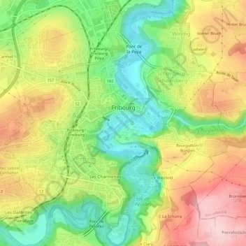
Nombre: Mapa topográfico Fribourg - Freiburg, altitud, relieve.
Lugar: Fribourg - Freiburg, Sarine District, Fribourg, Switzerland (46.78489 7.13565 46.82155 7.18397)
Altitud media: 638 m
Altitud mínima: 528 m
Altitud máxima: 760 m
Haz una donación
Equípate para tu próxima aventura:
Como asociado de Amazon, este sitio gana comisiones por las compras que califican, sin ningún costo adicional para usted.
Otros mapas topográficos
Haga clic en un mapa para ver su topografía, su altitud y su relieve.