
Mapa topográfico Kopaonik
Mapa interactivo
Haga clic en el mapa para ver la altitud.
Acerca de este mapa
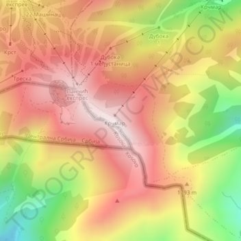
Nombre: Mapa topográfico Kopaonik, altitud, relieve.
Altitud media: 1.733 m
Altitud mínima: 1.334 m
Altitud máxima: 2.004 m
The national park is situated on a relatively flat region, at an altitude of about 1,700 m (5,577 ft). This central Kopaonik plateau is called Suvo Rudište. It is surrounded by mountain peaks. To the north and northwest of this plateau stretches Banjski Kopaonik, which is the location of Jošanička Banja spa, whose strong springs' waters reach the temperature of 88 °C (190 °F). Directly below the Suvo Rudište plateau starts the valley of the Samokovska River, with its steep run, numerous rapids, falls and gorges. Kopaonik has over 200 sunny days annually and over 160 days covered by snow. There is also the Jelovarnik falls, one of the highest in Serbia.