
Haz una donación
Equípate para tu próxima aventura:
Como asociado de Amazon, este sitio gana comisiones por las compras que califican, sin ningún costo adicional para usted.
Mapa topográfico Täsch
Haga clic en el mapa para ver la altitud.
Haz una donación
Equípate para tu próxima aventura:
Como asociado de Amazon, este sitio gana comisiones por las compras que califican, sin ningún costo adicional para usted.
Acerca de este mapa
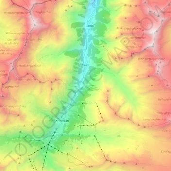
Nombre: Mapa topográfico Täsch, altitud, relieve.
Lugar: Täsch, Visp, Wallis, 3929, Switzerland (46.01622 7.69006 46.08467 7.89458)
Altitud media: 2.811 m
Altitud mínima: 1.284 m
Altitud máxima: 4.532 m
Haz una donación
Equípate para tu próxima aventura:
Como asociado de Amazon, este sitio gana comisiones por las compras que califican, sin ningún costo adicional para usted.
Otros mapas topográficos
Haga clic en un mapa para ver su topografía, su altitud y su relieve.
Zermatt
Switzerland > Wallis > Visp > Zermatt > Zermatt
It lies at the upper end of Mattertal at an elevation of 1,620 m (5,310 ft), at the foot of Switzerland's highest peaks. It lies about 10 km (6.2 mi) from the over 3,292 m (10,801 ft) high Theodul Pass bordering Italy. Zermatt is the southernmost commune of the German Sprachraum.
Altitud media: 2.469 m