
Mapa topográfico Hohenwart
Haga clic en el mapa para ver la altitud.
Hohenwart
2018 gab es nach der amtlichen Statistik in der Gemeinde 2054 sozialversicherungspflichtige Arbeitsplätze. Von der Wohnbevölkerung standen 1745 Personen in einer versicherungspflichtigen Tätigkeit. Die Zahl der Einpendler war um 209 Personen höher als die der Auspendler. Von den Einwohnern waren 27 arbeitslos. Die 95 landwirtschaftlichen Betriebe (Stand 2016) bewirtschafteten insgesamt 2879 Hektar Nutzfläche.
Acerca de este mapa
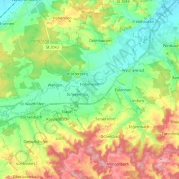
Nombre: Mapa topográfico Hohenwart, altitud, relieve.
Altitud media: 435 m
Altitud mínima: 379 m
Altitud máxima: 527 m
Otros mapas topográficos
Haga clic en un mapa para ver su topografía, su altitud y su relieve.
Straßhöfe
Deutschland > Bayern > Landkreis Pfaffenhofen an der Ilm > Rohrbach an der Ilm
Altitud media: 426 m
Gotteshofen
Deutschland > Bayern > Landkreis Pfaffenhofen an der Ilm > Reichertshofen > Reichertshofen
Altitud media: 388 m
Pleiling
Deutschland > Bayern > Landkreis Pfaffenhofen an der Ilm > Vohburg an der Donau > Pleiling
Altitud media: 400 m
Untermettenbach
Deutschland > Bayern > Landkreis Pfaffenhofen an der Ilm > Geisenfeld > Untermettenbach
Altitud media: 420 m
Weingarten
Deutschland > Bayern > Landkreis Pfaffenhofen an der Ilm > Pfaffenhofen an der Ilm > Haimpertshofen
Altitud media: 451 m
Haimpertshofen
Deutschland > Bayern > Landkreis Pfaffenhofen an der Ilm > Pfaffenhofen an der Ilm
Altitud media: 448 m
Engelbrechtsmünster
Deutschland > Bayern > Landkreis Pfaffenhofen an der Ilm > Geisenfeld
Altitud media: 383 m
Siebeneichmühle
Deutschland > Bayern > Landkreis Pfaffenhofen an der Ilm > Pfaffenhofen an der Ilm > Affalterbach
Altitud media: 440 m
Wasenstatt
Deutschland > Bayern > Landkreis Pfaffenhofen an der Ilm > Pfaffenhofen an der Ilm > Göbelsbach
Altitud media: 451 m
Gambach
Deutschland > Bayern > Landkreis Pfaffenhofen an der Ilm > Rohrbach an der Ilm
Altitud media: 440 m
Tegernbach
Deutschland > Bayern > Landkreis Pfaffenhofen an der Ilm > Pfaffenhofen an der Ilm > Tegernbach
Altitud media: 458 m
Knodorf
Deutschland > Bayern > Landkreis Pfaffenhofen an der Ilm > Vohburg an der Donau
Altitud media: 360 m
Affalterbach
Deutschland > Bayern > Landkreis Pfaffenhofen an der Ilm > Pfaffenhofen an der Ilm > Affalterbach
Altitud media: 439 m
Siebeneich
Deutschland > Bayern > Landkreis Pfaffenhofen an der Ilm > Kohlstatt > Siebeneich
Altitud media: 497 m
Jebertshausen
Deutschland > Bayern > Landkreis Pfaffenhofen an der Ilm > Wolnzach > Jebertshausen
Altitud media: 449 m
Sankt Kastl
Deutschland > Bayern > Landkreis Pfaffenhofen an der Ilm > Stöffel > Sankt Kastl
Altitud media: 432 m
Oberhartheim
Deutschland > Bayern > Landkreis Pfaffenhofen an der Ilm > Vohburg an der Donau
Altitud media: 394 m