
Haz una donación
Equípate para tu próxima aventura:
Como asociado de Amazon, este sitio gana comisiones por las compras que califican, sin ningún costo adicional para usted.
Mapa topográfico Mount Washington
Haga clic en el mapa para ver la altitud.
Haz una donación
Equípate para tu próxima aventura:
Como asociado de Amazon, este sitio gana comisiones por las compras que califican, sin ningún costo adicional para usted.
Mount Washington
Mount Washington is located on a plateau in the Taconic Mountains. To the east, Mount Everett, the highest point in town and the highest point in the southern Taconic Mountains, rises 2,602 feet (793 m) near the town's eastern border. To the north, several mountains and hills lie along the Egremont town line. Alander Mountain and the western escarpment of the southern Taconic Mountains lie along the western border of Mount Washington at the Columbia County, New York line. To the south, along the Connecticut border, stands another series of peaks including Mount Frissell. Although the summit of this mountain rests within the town of Mount Washington, its southern slope is located in Connecticut and is that state's highest elevation. Many brooks lie within the town, most of which feed into Roeliff Jansen Kill in Copake, New York. Mount Washington State Forest makes up a large portion of the town, as does Mount Everett State Reservation. The town is also home to Bash Bish Falls State Park, which is centered around its eponymous falls. The Appalachian Trail enters Massachusetts in Mount Washington, coming from Bear Mountain, then turning east before following near the eastern town border, over Mount Race and Mount Everett, before heading into Egremont.
Haz una donación
Equípate para tu próxima aventura:
Como asociado de Amazon, este sitio gana comisiones por las compras que califican, sin ningún costo adicional para usted.
Acerca de este mapa
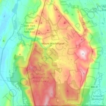
Nombre: Mapa topográfico Mount Washington, altitud, relieve.
Altitud media: 400 m
Altitud mínima: 160 m
Altitud máxima: 783 m
Haz una donación
Equípate para tu próxima aventura:
Como asociado de Amazon, este sitio gana comisiones por las compras que califican, sin ningún costo adicional para usted.
Otros mapas topográficos
Haga clic en un mapa para ver su topografía, su altitud y su relieve.
Mount Everett
United States > Massachusetts > Berkshire County
Mount Everett helps divide the watersheds of the Hudson and Housatonic rivers. Its eastern slopes share a larger escarpment with Mount Race and Bear Mountain plus several related summits. This escarpment rises from an elevation around 700 feet in Sheffield's Housatonic Valley at a mean angle of about 20…
Altitud media: 561 m
Mount Greylock
United States > Massachusetts > Berkshire County > Adams
Geographically, Mount Greylock is part of an 11-mile-long (18 km) by 4+1⁄2-mile-wide (7 km) island-like range that runs north-south between the Hoosac Range to the east, the Green Mountains to the north, the Berkshires to both the south and east, and the Taconic Mountains to the west with which it is…
Altitud media: 746 m
Haz una donación
Equípate para tu próxima aventura:
Como asociado de Amazon, este sitio gana comisiones por las compras que califican, sin ningún costo adicional para usted.
Berkshire Heights
United States > Massachusetts > Berkshire County > Great Barrington
Altitud media: 243 m
Haz una donación
Equípate para tu próxima aventura:
Como asociado de Amazon, este sitio gana comisiones por las compras que califican, sin ningún costo adicional para usted.
Pittsfield
United States > Massachusetts > Berkshire County
Pittsfield has a humid continental climate (Dfb). Winters are harsh due the city's high elevation at 1,039 ft (317 m), with an average annual snowfall of 75.9 inches (1,930 mm) and temperatures dipping to 0 °F (−18 °C) or colder 13 times per year. Summers, however, are typically warm and pleasant, with…
Altitud media: 433 m
Mount Greylock
United States > Massachusetts > Berkshire County > Adams
Northern hardwood forest characterize lower and mid-elevations, while upper slopes are covered with balsam fir and red spruce as well as American mountain ash. About 555 acres (225 hectares) of old growth forest have been inventoried within the Greylock Range, including tree specimens up to 350 years old. On…
Altitud media: 746 m
Haz una donación
Equípate para tu próxima aventura:
Como asociado de Amazon, este sitio gana comisiones por las compras que califican, sin ningún costo adicional para usted.
Haz una donación
Equípate para tu próxima aventura:
Como asociado de Amazon, este sitio gana comisiones por las compras que califican, sin ningún costo adicional para usted.
Clover Hill Farm Conservation Area
United States > Massachusetts > Berkshire County > Williamstown > Meadowvale
Altitud media: 217 m
Haz una donación
Equípate para tu próxima aventura:
Como asociado de Amazon, este sitio gana comisiones por las compras que califican, sin ningún costo adicional para usted.
Richmond Pond
United States > Massachusetts > Berkshire County > Richmond > Camp Russell
Altitud media: 353 m
March Cataract Falls
United States > Massachusetts > Berkshire County > Williamstown
Altitud media: 765 m
Greylock
United States > Massachusetts > Berkshire County > North Adams > Greylock
Altitud media: 314 m
Haz una donación
Equípate para tu próxima aventura:
Como asociado de Amazon, este sitio gana comisiones por las compras que califican, sin ningún costo adicional para usted.
Mountain Meadow Preserve
United States > Massachusetts > Berkshire County > Williamstown
Altitud media: 267 m
Haz una donación
Equípate para tu próxima aventura:
Como asociado de Amazon, este sitio gana comisiones por las compras que califican, sin ningún costo adicional para usted.
Mount Frissell
United States > Massachusetts > Berkshire County > Mount Washington
Altitud media: 614 m