
Mapa topográfico Peachtree City
Mapa interactivo
Haga clic en el mapa para ver la altitud.
Acerca de este mapa
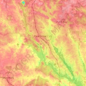
Nombre: Mapa topográfico Peachtree City, altitud, relieve.
Altitud media: 262 m
Altitud mínima: 180 m
Altitud máxima: 309 m
Shakerag Hill, with an elevation of 980 feet (300 m), is the highest point in the city and sits on the eastern border at the intersection of GA Hwy 54 and Robinson Road.
Otros mapas topográficos
Haga clic en un mapa para ver su topografía, su altitud y su relieve.
Huntington Place
United States > Georgia > Fayette County > Peachtree City
Huntington Place, Peachtree City, Fayette County, Georgia, 30269, United States
Altitud media: 249 m
Fayetteville
United States > Georgia > Fayette County
Fayetteville, Fayette County, Georgia, United States
Altitud media: 265 m
Tamerlane
United States > Georgia > Fayette County > Peachtree City > Tamerlane
Tamerlane, Peachtree City, Fayette County, Georgia, 30269, United States
Altitud media: 247 m