
Mapa topográfico Leavenworth
Mapa interactivo
Haga clic en el mapa para ver la altitud.
Acerca de este mapa
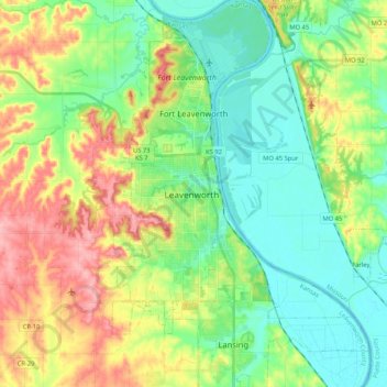
Nombre: Mapa topográfico Leavenworth, altitud, relieve.
Lugar: Leavenworth, Leavenworth County, Kansas, United States (39.23071 -94.96500 39.39245 -94.88074)
Altitud media: 268 m
Altitud mínima: 225 m
Altitud máxima: 345 m
Otros mapas topográficos
Haga clic en un mapa para ver su topografía, su altitud y su relieve.
Maywood
United States > Kansas > Leavenworth County > Leavenworth
Maywood, Leavenworth, Leavenworth County, Kansas, 64092, United States
Altitud media: 246 m
Fairmount
United States > Kansas > Leavenworth County
Fairmount, Leavenworth County, Kansas, United States
Altitud media: 290 m
Linwood
United States > Kansas > Leavenworth County
Linwood, Leavenworth County, Kansas, United States
Altitud media: 248 m
Hoge
United States > Kansas > Leavenworth County
Hoge, Leavenworth County, Kansas, United States
Altitud media: 276 m
Basehor
United States > Kansas > Leavenworth County
Basehor, Leavenworth County, Kansas, 66007, United States
Altitud media: 286 m
Fort Leavenworth
United States > Kansas > Leavenworth County > Leavenworth > Leavenworth
Fort Leavenworth, Leavenworth, Leavenworth County, Kansas, 66027, United States
Altitud media: 252 m
Lansing
United States > Kansas > Leavenworth County
Lansing, Leavenworth County, Kansas, 66043, United States
Altitud media: 266 m
Leavenworth
United States > Kansas > Leavenworth County > Leavenworth
Leavenworth, Leavenworth County, Kansas, 66048, United States
Altitud media: 277 m