
Mapa topográfico Chelmsford
Haga clic en el mapa para ver la altitud.
Acerca de este mapa
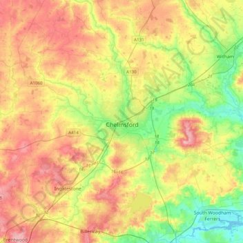
Nombre: Mapa topográfico Chelmsford, altitud, relieve.
Lugar: Chelmsford, Essex, England, United Kingdom (51.61662 0.33216 51.85748 0.64898)
Altitud media: 54 m
Altitud mínima: -1 m
Altitud máxima: 113 m
Otros mapas topográficos
Haga clic en un mapa para ver su topografía, su altitud y su relieve.
Coles Green
United Kingdom > England > Essex > Uttlesford > Berden > Little London
Altitud media: 100 m
Nazeing Gate
United Kingdom > England > Essex > Epping Forest > Bumble's Green > Nazeing
Altitud media: 70 m
Roughtalley's Wood (South) & Epping Forest Woodland Burial Ground
United Kingdom > England > Essex > Epping Forest > Coopersale
Altitud media: 96 m
Watch House Green
United Kingdom > England > Essex > Uttlesford > Felsted > Watch House Green
Altitud media: 69 m
Wivenhoe Woods
United Kingdom > England > Essex > Colchester > Wivenhoe > Rowhedge
Altitud media: 18 m