
Haz una donación
Equípate para tu próxima aventura:
Como asociado de Amazon, este sitio gana comisiones por las compras que califican, sin ningún costo adicional para usted.
Mapa topográfico Derry/Londonderry
Haga clic en el mapa para ver la altitud.
Haz una donación
Equípate para tu próxima aventura:
Como asociado de Amazon, este sitio gana comisiones por las compras que califican, sin ningún costo adicional para usted.
Derry/Londonderry
Derry is characterised by its distinctively hilly topography. The River Foyle forms a deep valley as it flows through the city, making Derry a place of very steep streets and sudden, startling views. The original walled city of Londonderry lies on a hill on the west bank of the River Foyle. In the past, the river branched and enclosed this wooded hill as an island; over the centuries, however, the western branch of the river dried up and became a low-lying and boggy district that is now called the Bogside.
Haz una donación
Equípate para tu próxima aventura:
Como asociado de Amazon, este sitio gana comisiones por las compras que califican, sin ningún costo adicional para usted.
Acerca de este mapa
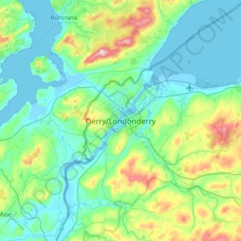
Nombre: Mapa topográfico Derry/Londonderry, altitud, relieve.
Altitud media: 88 m
Altitud mínima: -5 m
Altitud máxima: 478 m
Haz una donación
Equípate para tu próxima aventura:
Como asociado de Amazon, este sitio gana comisiones por las compras que califican, sin ningún costo adicional para usted.
Otros mapas topográficos
Haga clic en un mapa para ver su topografía, su altitud y su relieve.
Drumahoe
United Kingdom > Northern Ireland > County Londonderry > Derry/Londonderry
Altitud media: 46 m
Causeway Coast and Glens District
United Kingdom > Northern Ireland > County Londonderry
Altitud media: 101 m
Ballymagroarty
United Kingdom > Northern Ireland > County Londonderry > Derry/Londonderry
Altitud media: 73 m
Haz una donación
Equípate para tu próxima aventura:
Como asociado de Amazon, este sitio gana comisiones por las compras que califican, sin ningún costo adicional para usted.
Mid-Ulster District Council
United Kingdom > Northern Ireland > County Londonderry
Altitud media: 112 m
Haz una donación
Equípate para tu próxima aventura:
Como asociado de Amazon, este sitio gana comisiones por las compras que califican, sin ningún costo adicional para usted.
Lough Foyle
United Kingdom > Northern Ireland > County Londonderry > Londonderry/Derry
Altitud media: 61 m
Bay Road Park
United Kingdom > Northern Ireland > County Londonderry > Derry/Londonderry
Altitud media: 19 m
Haz una donación
Equípate para tu próxima aventura:
Como asociado de Amazon, este sitio gana comisiones por las compras que califican, sin ningún costo adicional para usted.