
Haz una donación
Equípate para tu próxima aventura:
Como asociado de Amazon, este sitio gana comisiones por las compras que califican, sin ningún costo adicional para usted.
Mapa topográfico Bountiful
Haga clic en el mapa para ver la altitud.
Haz una donación
Equípate para tu próxima aventura:
Como asociado de Amazon, este sitio gana comisiones por las compras que califican, sin ningún costo adicional para usted.
Acerca de este mapa
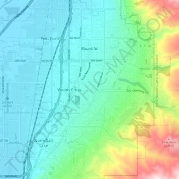
Nombre: Mapa topográfico Bountiful, altitud, relieve.
Lugar: Bountiful, Davis County, Utah, 84010, United States (40.83291 -111.90212 40.91028 -111.81538)
Altitud media: 1.477 m
Altitud mínima: 1.280 m
Altitud máxima: 2.160 m
Haz una donación
Equípate para tu próxima aventura:
Como asociado de Amazon, este sitio gana comisiones por las compras que califican, sin ningún costo adicional para usted.
Otros mapas topográficos
Haga clic en un mapa para ver su topografía, su altitud y su relieve.
Antelope Island
United States > Utah > Davis County
The island is accessible via a 7-mile causeway from Syracuse in Davis County. Access from Interstate 15 is via exit 332, then west along Antelope Drive (SR-108). The island's shore (all but west side of the island) is mostly flat with beaches and plains to the base of the mountains on the island. These steep…
Altitud media: 1.306 m
Haz una donación
Equípate para tu próxima aventura:
Como asociado de Amazon, este sitio gana comisiones por las compras que califican, sin ningún costo adicional para usted.
Haz una donación
Equípate para tu próxima aventura:
Como asociado de Amazon, este sitio gana comisiones por las compras que califican, sin ningún costo adicional para usted.
Mount Lebannon Acres
United States > Utah > Davis County > Centerville > Rosedale
Altitud media: 1.464 m