

Mapa topográfico Bacup
Haga clic en el mapa para ver la altitud.
Bacup
The geology and topography of the village lent itself to urbanisation and domestic industries; primitive weavers' cottages, coal pits and stone quarries were propelled by Bacup's natural supply of water power in the Early Modern period. The adoption of the factory system, which developed into the Industrial Revolution, enabled the transformation of Bacup from a small rural village into a mill town, populated by an influx of families attracted by Bacup's cotton mills, civic amenities and regional railway network. Locally sourced coal provided the fuel for industrial-scale quarrying, cotton spinning and shoemaking operations, stimulating the local economy. Bacup received a charter of incorporation in 1882, giving it honorific borough status and its own elected town government, consisting of a mayor, aldermen and councillors to oversee local affairs.
Acerca de este mapa
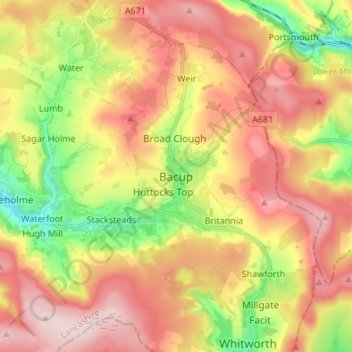
Nombre: Mapa topográfico Bacup, altitud, relieve.
Altitud media: 337 m
Altitud mínima: 180 m
Altitud máxima: 477 m
Otros mapas topográficos
Haga clic en un mapa para ver su topografía, su altitud y su relieve.
Clowbridge
United Kingdom > England > Lancashire > Borough of Rossendale > Habergham Eaves
Altitud media: 319 m

Cowm Reservoir
United Kingdom > England > Lancashire > Borough of Rossendale > Whitworth > Shawforth
Altitud media: 302 m