
Haz una donación
Equípate para tu próxima aventura:
Como asociado de Amazon, este sitio gana comisiones por las compras que califican, sin ningún costo adicional para usted.
Mapa topográfico Garoowe
Haga clic en el mapa para ver la altitud.
Haz una donación
Equípate para tu próxima aventura:
Como asociado de Amazon, este sitio gana comisiones por las compras que califican, sin ningún costo adicional para usted.
Garoowe
Garowe is situated in the Nugaal Valley, bounded by gradually ascending high plateaus that generally reach elevations of 500 to 1,000 metres (1,600 to 3,300 feet) above sea level on the north, west, and south. The western part of the same plateau is crossed by numerous valleys and dry watercourses. Raising livestock forms the basis of the economy, and frankincense and myrrh are collected from the wild trees.
Haz una donación
Equípate para tu próxima aventura:
Como asociado de Amazon, este sitio gana comisiones por las compras que califican, sin ningún costo adicional para usted.
Acerca de este mapa
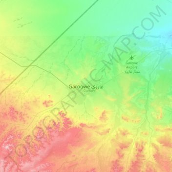
Nombre: Mapa topográfico Garoowe, altitud, relieve.
Lugar: Garoowe, Garowe District, Nugaal, Puntland, Somalia (8.24614 48.32320 8.56614 48.64320)
Altitud media: 486 m
Altitud mínima: 395 m
Altitud máxima: 645 m
Haz una donación
Equípate para tu próxima aventura:
Como asociado de Amazon, este sitio gana comisiones por las compras que califican, sin ningún costo adicional para usted.