Geolocalizar

Mapa topográfico Braunlage

Mapa interactivo

Haga clic en el mapa para ver la altitud.

Acerca de este mapa

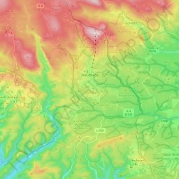
Nombre: Mapa topográfico Braunlage, altitud, relieve.

Lugar: Braunlage, Landkreis Goslar, Lower Saxony, Germany (51.65043 10.49042 51.78087 10.68399)

Altitud media: 617 m

Altitud mínima: 365 m

Altitud máxima: 967 m

Braunlage is located on the Warme Bode, a headstream of the river Bode, close to the border with Elend in the state of Saxony-Anhalt. The municipal area stretches along the south-eastern rim of the Harz National Park from an elevation of 550 m (1,800 ft) up to 971 m (3,186 ft) at the summit of the Wurmberg. Other peaks in the vicinity include the Achtermannshöhe and the Hahnenklee Crags.

Wikipedia (CC-BY-SA 3.0)

Otros mapas topográficos

Haga clic en un mapa para ver su topografía, su altitud y su relieve.

Hohegeiß

Germany > Lower Saxony > Landkreis Goslar > Braunlage

Hohegeiß, Braunlage, Landkreis Goslar, Lower Saxony, Germany

Altitud media: 568 m

Sankt Andreasberg

Germany > Lower Saxony > Landkreis Goslar > Braunlage

Sankt Andreasberg, Braunlage, Landkreis Goslar, Lower Saxony, Germany

Altitud media: 648 m

Altenau

Germany > Lower Saxony > Landkreis Goslar > Clausthal-Zellerfeld

Altenau, Altenau - Schulenberg i.O., Clausthal-Zellerfeld, Landkreis Goslar, Lower Saxony, Germany

Altitud media: 599 m

Lochtum

Germany > Lower Saxony > Landkreis Goslar > Goslar

Lochtum, Goslar, Landkreis Goslar, Lower Saxony, Germany

Altitud media: 196 m

Langelsheim (Innenstadt)

Germany > Lower Saxony > Landkreis Goslar > Langelsheim (Innenstadt)

Langelsheim (Innenstadt), Langelsheim, Landkreis Goslar, Lower Saxony, 38685, Germany

Altitud media: 257 m

Clausthal-Zellerfeld

Germany > Lower Saxony > Landkreis Goslar

Clausthal-Zellerfeld, Landkreis Goslar, Lower Saxony, Germany

Altitud media: 466 m