
Mapa topográfico Burnley
Mapa interactivo
Haga clic en el mapa para ver la altitud.
Acerca de este mapa
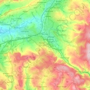
Nombre: Mapa topográfico Burnley, altitud, relieve.
Lugar: Burnley, Lancashire, England, United Kingdom (53.72300 -2.34231 53.82526 -2.11228)
Altitud media: 247 m
Altitud mínima: 63 m
Altitud máxima: 479 m
The town lies in a natural three-forked valley at the confluence of the River Brun and the River Calder, surrounded by open fields, with wild moorland at higher altitudes. To the west of Burnley lie the towns of Padiham, Accrington and Blackburn, with Nelson and Colne to the north. The centre of the town stands at approximately 387 feet (118 m) above sea level and 30 miles (48 km) east of the Irish Sea coast.
Otros mapas topográficos
Haga clic en un mapa para ver su topografía, su altitud y su relieve.
Waddington
United Kingdom > England > Lancashire > Ribble Valley
Waddington, Ribble Valley, Lancashire, England, United Kingdom
Altitud media: 164 m
Great Eccleston
United Kingdom > England > Lancashire > Borough of Wyre
Great Eccleston, Borough of Wyre, Lancashire, England, United Kingdom
Altitud media: 12 m
Wymott
United Kingdom > England > Lancashire > Chorley
Wymott, Ulnes Walton, Chorley, Lancashire, England, PR26 8NH, United Kingdom
Altitud media: 17 m
Croston
United Kingdom > England > Lancashire > Chorley
Croston, Chorley, Lancashire, England, United Kingdom
Altitud media: 8 m
Fleetwood
United Kingdom > England > Lancashire > Borough of Wyre
Fleetwood, Borough of Wyre, Lancashire, England, United Kingdom
Altitud media: 2 m
Leyland
United Kingdom > England > Lancashire > South Ribble
Leyland, South Ribble, Lancashire, England, PR25 2EX, United Kingdom
Altitud media: 41 m
Read
United Kingdom > England > Lancashire > Ribble Valley
Read, Ribble Valley, Lancashire, England, United Kingdom
Altitud media: 114 m
Lytham St Annes
United Kingdom > England > Lancashire > Fylde > Lytham St Annes
Lytham St Annes, Fylde, Lancashire, North West England, England, FY8 4AR, United Kingdom
Altitud media: 5 m
Jamacia Wood
United Kingdom > England > Lancashire > Ribble Valley > Langho
Jamacia Wood, Billington and Langho, Langho, Ribble Valley, Lancashire, England, United Kingdom
Altitud media: 100 m