
Haz una donación
Equípate para tu próxima aventura:
Como asociado de Amazon, este sitio gana comisiones por las compras que califican, sin ningún costo adicional para usted.
Mapa topográfico McHenry
Haga clic en el mapa para ver la altitud.
Haz una donación
Equípate para tu próxima aventura:
Como asociado de Amazon, este sitio gana comisiones por las compras que califican, sin ningún costo adicional para usted.
McHenry
It rests at an elevation of 797 feet and the Fox River flows through the eastern portion of the city. It is surrounded by natural lakes and streams, grassy moraine hills, gravel banks and shallow nutrient-rich peat bogs, remnants of receding glaciers from the last ice age. Moraine Hills State Park, Glacial Park Conservation Area, and Volo Bog State Natural Area preserve some of these natural features.
Haz una donación
Equípate para tu próxima aventura:
Como asociado de Amazon, este sitio gana comisiones por las compras que califican, sin ningún costo adicional para usted.
Acerca de este mapa
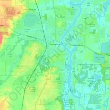
Nombre: Mapa topográfico McHenry, altitud, relieve.
Lugar: McHenry, McHenry County, Illinois, 60050, United States (42.29938 -88.34578 42.37125 -88.23793)
Altitud media: 237 m
Altitud mínima: 218 m
Altitud máxima: 282 m
Haz una donación
Equípate para tu próxima aventura:
Como asociado de Amazon, este sitio gana comisiones por las compras que califican, sin ningún costo adicional para usted.
Otros mapas topográficos
Haga clic en un mapa para ver su topografía, su altitud y su relieve.
Riley
United States > Illinois > McHenry County
Riley, elevation 807 feet (246 m), is an unincorporated community and census-designated place in McHenry County, Illinois, United States. It was named a CDP before the 2020 census, at which time it had a population of 10.
Altitud media: 250 m
Haz una donación
Equípate para tu próxima aventura:
Como asociado de Amazon, este sitio gana comisiones por las compras que califican, sin ningún costo adicional para usted.