
Mapa topográfico Bedford
Mapa interactivo
Haga clic en el mapa para ver la altitud.
Bedford
There is a popular walkway along much of the Bedford Basin waterfront that begins at DeWolf park, and continues as the Bedford-Sackville Connector Greenway, a crushed gravel covered trail that meanders along the Sackville River. There is an outdoor 25m pool and smaller splash pool located at the Lions Park on Shore Drive. In the summer there are numerous lakes suitable for swimming. The topography of the area limits the possible locations for soccer and football fields. However, there are fields at Basinview Drive Community School, Sunnyside Elementary (Eaglewood location), Rocky Lake Junior High, Charles P. Allen High School, Bedford South School, and Range Park. The community is currently home to six ice surfaces, at the Lebrun Centre, the Gary Martin Dome and the BMO Centre. Bedford is a well-established sailing community, and is home to the Bedford Basin Yacht Club and Marina.
Acerca de este mapa
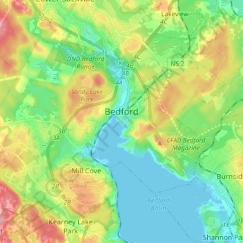
Nombre: Mapa topográfico Bedford, altitud, relieve.
Lugar: Bedford, Halifax, Halifax County, Nova Scotia, Canada (44.69272 -63.73305 44.76000 -63.60277)
Altitud media: 46 m
Altitud mínima: -1 m
Altitud máxima: 134 m