
Mapa topográfico Telluride
Mapa interactivo
Haga clic en el mapa para ver la altitud.
Acerca de este mapa
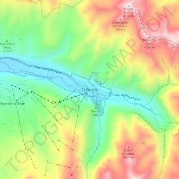
Nombre: Mapa topográfico Telluride, altitud, relieve.
Altitud media: 3.246 m
Altitud mínima: 2.638 m
Altitud máxima: 4.135 m
Telluride has an elevation of 8,750 feet (2,670 m) in an isolated spot in Southwest Colorado. From the west, Colorado Route 145 is the most common way into Telluride; two other passes enter the town, Imogene Pass and Black Bear Pass.