
Mapa topográfico Antipas
Mapa interactivo
Haga clic en el mapa para ver la altitud.
Acerca de este mapa
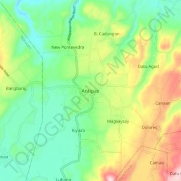
Nombre: Mapa topográfico Antipas, altitud, relieve.
Lugar: Antipas, Cotabato, Soccsksargen, Philippines (7.20764 125.01519 7.28764 125.09519)
Altitud media: 318 m
Altitud mínima: 151 m
Altitud máxima: 625 m
Temperature ranges from 23 to 32 degrees Celsius, because of its topographic elevation of 320 meters above sea level and proximity to mountainous Bukidnon province, making it one of the cool places in Soccsksargen. The highest temperature is felt during the months of March and April, while the lowest is in December. The long dry season usually lasts from January to April, during which months there is also a marked decrease in water supply for agricultural purposes when some water sources dry up, affecting agricultural productivity. During the peak rainy season, some rivers/creeks overflow, causing low-lying areas to flood.