
Haz una donación
Equípate para tu próxima aventura:
Como asociado de Amazon, este sitio gana comisiones por las compras que califican, sin ningún costo adicional para usted.
Mapa topográfico Silver City
Haga clic en el mapa para ver la altitud.
Haz una donación
Equípate para tu próxima aventura:
Como asociado de Amazon, este sitio gana comisiones por las compras que califican, sin ningún costo adicional para usted.
Acerca de este mapa
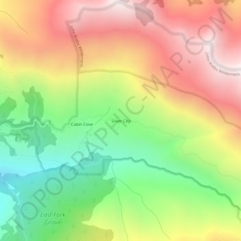
Nombre: Mapa topográfico Silver City, altitud, relieve.
Lugar: Silver City, Tulare County, California, United States (36.44605 -118.66593 36.48605 -118.62593)
Altitud media: 2.353 m
Altitud mínima: 1.699 m
Altitud máxima: 3.032 m
Haz una donación
Equípate para tu próxima aventura:
Como asociado de Amazon, este sitio gana comisiones por las compras que califican, sin ningún costo adicional para usted.
Otros mapas topográficos
Haga clic en un mapa para ver su topografía, su altitud y su relieve.
Sequoia National Park
United States > California > Tulare County
Many park visitors enter Sequoia National Park through its southern entrance near the town of Three Rivers at Ash Mountain at 1,700 ft (520 m) elevation. The lower elevations around Ash Mountain contain the only National Park Service-protected California Foothills ecosystem, consisting of blue oak woodlands,…
Altitud media: 2.515 m
Porterville
United States > California > Tulare County
Porterville, lying along the foothills of the Sierras at an elevation of 455 feet (139 m), is located on State Highway 65, 165 miles (266 km) north of Los Angeles, and 171 miles (275 km) east of the Pacific Coast. The city has a strategic central location to major markets and a ready access to major…
Altitud media: 175 m
Haz una donación
Equípate para tu próxima aventura:
Como asociado de Amazon, este sitio gana comisiones por las compras que califican, sin ningún costo adicional para usted.
Dinuba
United States > California > Tulare County
According to the United States Census Bureau, the city has a total area of 6.5 square miles (17 km2), all of it land. The general topography is quite level ground, at an elevation of approximately 345 feet (105 m) above mean sea datum. The gradient is approximately ten feet per mile, from east-northeast to…
Altitud media: 107 m
Mountain Home Demonstration State Forest
United States > California > Tulare County
Altitud media: 1.860 m
Kennedy Meadows
United States > California > Tulare County
The Kennedy Meadows area is at approximately 6200 feet elevation. The most common access route is by the steep Sherman Pass Road from U.S. Route 395 near Pearsonville. Other routes are possible but much slower.
Altitud media: 1.992 m
Haz una donación
Equípate para tu próxima aventura:
Como asociado de Amazon, este sitio gana comisiones por las compras que califican, sin ningún costo adicional para usted.
Sequoia National Park
United States > California > Tulare County
Many park visitors enter Sequoia National Park through its southern entrance near the town of Three Rivers at Ash Mountain at 1,700 ft (520 m) elevation. The lower elevations around Ash Mountain contain the only National Park Service-protected California Foothills ecosystem, consisting of blue oak woodlands,…
Altitud media: 2.515 m
Haz una donación
Equípate para tu próxima aventura:
Como asociado de Amazon, este sitio gana comisiones por las compras que califican, sin ningún costo adicional para usted.
Haz una donación
Equípate para tu próxima aventura:
Como asociado de Amazon, este sitio gana comisiones por las compras que califican, sin ningún costo adicional para usted.
Haz una donación
Equípate para tu próxima aventura:
Como asociado de Amazon, este sitio gana comisiones por las compras que califican, sin ningún costo adicional para usted.
Sequoia National Park
United States > California > Tulare County
Many park visitors enter Sequoia National Park through its southern entrance near the town of Three Rivers at Ash Mountain at 1,700 ft (520 m) elevation. The lower elevations around Ash Mountain contain the only National Park Service-protected California Foothills ecosystem, consisting of blue oak woodlands,…
Altitud media: 2.515 m
Haz una donación
Equípate para tu próxima aventura:
Como asociado de Amazon, este sitio gana comisiones por las compras que califican, sin ningún costo adicional para usted.
Haz una donación
Equípate para tu próxima aventura:
Como asociado de Amazon, este sitio gana comisiones por las compras que califican, sin ningún costo adicional para usted.
Porterville
United States > California > Tulare County
Porterville, lying along the foothills of the Sierras at an elevation of 455 feet (139 m), is located on State Highway 65, 165 miles (266 km) north of Los Angeles, and 171 miles (275 km) east of the Pacific Coast. The city has a strategic central location to major markets and a ready access to major…
Altitud media: 175 m
Haz una donación
Equípate para tu próxima aventura:
Como asociado de Amazon, este sitio gana comisiones por las compras que califican, sin ningún costo adicional para usted.
Haz una donación
Equípate para tu próxima aventura:
Como asociado de Amazon, este sitio gana comisiones por las compras que califican, sin ningún costo adicional para usted.
Haz una donación
Equípate para tu próxima aventura:
Como asociado de Amazon, este sitio gana comisiones por las compras que califican, sin ningún costo adicional para usted.